

More extreme marine heatwaves for South Island
The heavy rainfall affecting the upper North Island is not the only unusual weather New Zealand is expecting at present. In the ocean off southern South Island, marine heatwaves of unprecedented strength are appearing. This is according to MetService oceanographer Dr Joao de Souza, who warns that for the second time this year, extreme marine heatwaves are forming in our southern seas.
Dr Souza tracks marine heatwaves as part of the MBIE-funded Moana Project. He explains that while New Zealand waters have seen almost uninterrupted marine heatwaves for a couple of years, the warming has now reached new levels.
When tracking marine heatwaves, MetService compares the current or forecasted temperature to the average of the last 25 years for each location and day of the year.
Dr Souza explains, “A marine heatwave is classified as temperatures that are higher than 90% of what we’ve seen in the past, i.e. the normal conditions. For Stewart Island at this time of year normal sea surface temperature is about 14.3 degrees, and the marine heatwave threshold is 15.3 degrees. Extreme marine heatwaves are when waters are warmer than four times the difference between normal conditions and the marine heatwave threshold. So for Stewart Island right now, extreme marine heatwave conditions are reached when the water temperature reaches 18.3 degrees. We are seeing steady temperatures above 18 degrees forecast for this weekend.”
“Extreme marine heatwaves are just that – extreme. It’s the highest category in existence for marine heatwaves, reflecting how unusual this level of warming is, both in New Zealand and internationally. And for the second time this year, we are now seeing extreme marine heatwaves building in New Zealand waters, this time near Stewart Island and Otago.”
“While you might expect a small blip in sea surface temperatures lasting a day, the heatwave that is now surrounding Stewart Island is concerning because 4-6 degree warming is forecasted to last 3 or 4 days."
He adds that MetService might have to extend the colour scale used to denote the warming. “Our graphics only go up to 5 degrees above normal, but now that we’re increasingly seeing even higher temperatures it may be time to change the scale. The warming is literally off the scale.”
The 7-day forecasted sea surface temperatures and how they differ from the 25-year average (called the temperature anomaly) for New Zealand’s ocean can be explored on SwellMap, the free MetService marine forecasting website. Users can zoom in to areas of interest and click on the map to get the exact temperature or difference from normal.
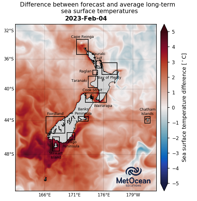
Map showing expected warming off Stewart Island and Otago Saturday 4 February. Image shows difference between forecasted sea surface temperatures and the long-term average for this time of year. Red shading indicates that the ocean is currently warmer than normal, blue that it is colder. Image from https://www.moanaproject.org/marine-heatwave-forecast.

Chart showing extreme marine heatwave conditions forecast for waters off Stewart Island this weekend.