

Understanding Ocean Modelling
When visiting the beach you can stand on the shore and observe the waves, you can swim to feel the currents and watch the tide as it rolls in and out. But ultimately you cannot determine what is happening at depth, what the conditions were like yesterday or what will happen tomorrow.
The only way we can picture this is by constructing representations of the oceans that simulate what is going on. Thanks to increasing computer power, ocean modelling is now a widespread tool used to represent ocean drivers and dynamics, which helps us look back on past, and predict future ocean conditions over time.
In the Moana Project, we often talk about models. Modelling is at the core of Ngā Ripo o Te Moana’s research with our New Zealand Marine heatwave forecast being a great example. Another is the soon-to-be-released MetOceanTrack particle tracking tool, which will allow us to, amongst other things, determine where kaimoana larvae travel in the ocean. But besides the interesting and informative outputs, what exactly are these models and how do they work?
What is modelling?
Models are simplified representations of reality; they aim to describe and understand the main processes and drivers of whatever it is you are modelling – in this case the ocean. In the Moana Project we use numerical ocean modelling, which is a combination of many mathematical equations that depends upon computers to find an approximate solution to an underlying physical problem.
These models mimic how nature behaves by recreating those physical and natural processes and are then used to provide insight into an area of uncertainty. For example, we can’t look at the coast of Kaikoura from land and know exactly what the ocean current speed and direction are, but we can use a model to estimate what is happening. The model can be run using historical data (observations collected in the past).

Figure 1: Ocean current speed and vectors (arrows showing the direction of flow) south of the Kaikoura Peninsula overlaid by the 200, 500, 800, 1000 meter contour lines, illustrating the shape of the Kaikoura Submarine Canyon. Model provided by Moana Project PhD student Phellipe Couto.
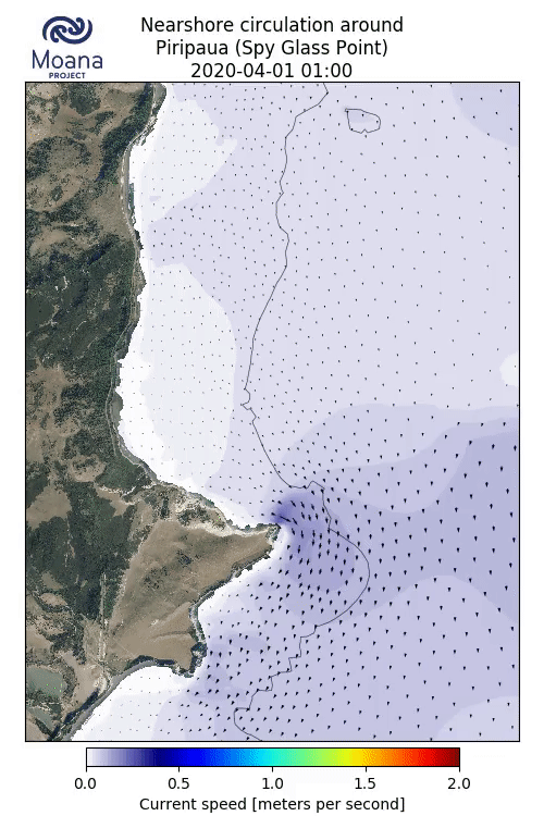
Figure 2: Strong nearshore currents (arrows showing the direction of flow) generated by the combined effects of tides, winds and waves during a large southern ocean swell event offshore Piripaua Point. Model provided by Moana Project PhD student Phellipe Couto.
What does an ocean circulation model look like?
An ocean circulation model is a group of code which solves the equations that describe the water movement and density fields over space and time to recreate real life physical processes. When you are running the model, you can see the output on the screen and the results of the variable that the model is calculating, for instance ocean current data in its raw form. These outputs move quickly on the screen which is how you know the model is evolving over time, and they are then presented in a more visually accessible interface like what you see on the website – the Moana Project’s Sea surface temperature forecast.

Figure 3: Ocean current data in its raw form.
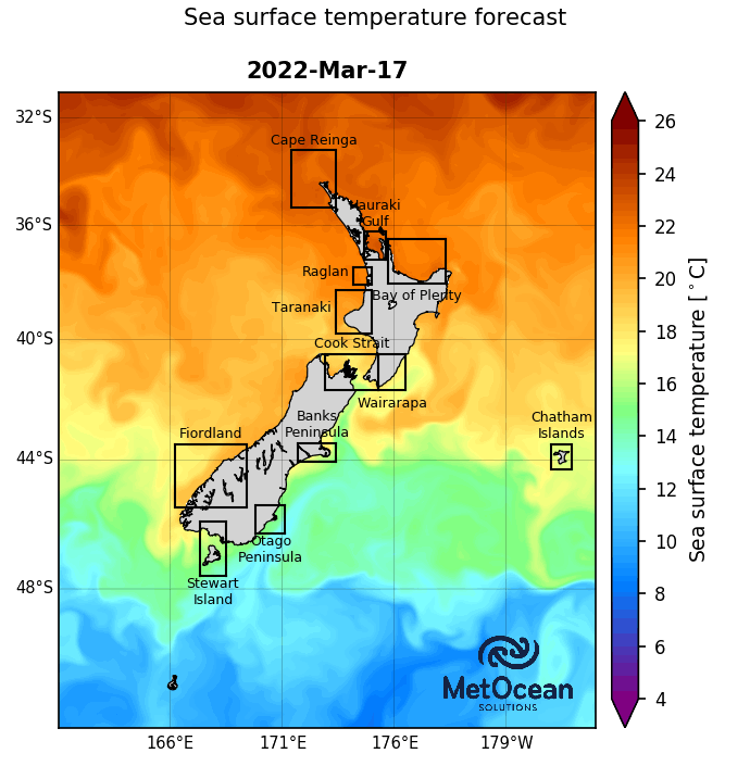 Figure 4: The Moana Project’s sea surface temperature forecast
How can you be sure that they work?
A model is essentially a ‘best guess’ but they are fairly accurate. Models are verified through validation which compares model predictions to ocean observations – for example the real temperature and salinity data. By doing this comparison, we can quantify statistically how well or poorly the model performed.
Models are regularly validated, and revalidated when the model code has changed, the context for the model's use has changed or when too much time has passed since the previous model validation.
In addition, state-of-the-art techniques of data assimilation (the science of combining various sources of information) combines and constrains the models with the observations to provide a final product that is better than the models or observations alone.
Why are models important?
Models help us visualise massive amounts of information in a simple way. Depending on the model itself, they can have many uses. Models you might be familiar with are: the weather forecast (atmospheric modelling) or the stock market (economic modelling) - these help us to make informed decisions.
One big benefit to modelling is even if you have observed data, models will spread that information over space and time. So instead of having information from a single site (e.g., a wave buoy), more information is available with a bigger temporal and spatial coverage through a model.
What models are in the Moana Project?
Moana backbone model:
A 25+ Year Hydrodynamic Hindcast Model is available through the Moana Backbone. This hindcast hosts an accurate and continuous 25+ year historic dataset (from 1993-2020) of current speeds, temperature, salinity and water levels for Aotearoa NZ’s Exclusive Economic Zone. This model is used as the ‘backbone’ for many oceanographic applications within the Moana Project, including the zoom-in models mentioned below.
Moana reanalysis model:
A 25-Year Hydrodynamic Hindcast Model that assimilates all the available ocean observations obtained from both international data centres and local institutions that did not make these available in the past. This simulation provides the best possible estimate of the ocean state by combining the model with real observations collected by oceanographic instruments.
Zoom-in models (Bay of Plenty, Kaikōura and Hauraki Gulf):
In the Moana Project, our PhD students are developing numerical models that are regionally specific, providing high-resolution models for the Bay of Plenty, Kaikōura and the Hauraki Gulf.
Moana forecast model:
The above models are used to provide 7-day operational forecasts of the ocean state each day. This provides information useful for planning activities that take place at sea (like fishing, aquaculture, operation of ports, etc.) and responding to changing ocean conditions, and is helpful for search and rescue operations, coastal inundations due to storm surge, etc.
And they can go on to create useful outputs, such as the Moana Project’s marine heatwave forecast which includes overview maps of sea surface temperatures happening, now in, and forecast for New Zealand waters as well as forecast graphs for several areas.
Ocean particle trajectory tracking tool:
This type of model tracks the movement of particles, which can help with tracking plastics, larvae, invasive species like the Asian date mussel or the Mediterranean fan worm, oil spills, vessels, contaminants, and lost persons.
How do you become an ocean modeller?
If you are curious about nature and have an interest in programming, ocean modelling could be for you. The basis is maths and physics, but in the end, we are recreating physical and natural processes in an effort to mimic nature. Your undergraduate study options could include physics, oceanography, earth science or even engineering too.
Contact us at info@moanaproject.org if you want some guidance, we would be happy to advise you on your oceanography journey.